Saturday, December 4, 2010
New title!
The book formerly known as "The Royal Miracle" is now titled "The September Queen"! Artwork is in progress and I can't wait to see what the cover will look like! I long ago fell way behind in chronicling my research adventures as my life was taken over by trying to complete the book on a rather punishing deadline. Eventually I'll try to post more of my travels with Alice and all around the internet, in search of knowledge about riding pillion, Jane and Charles's route, the genealogical history of the Lane family, Jane's correspondence with Elizabeth of Bohemia (Charles's aunt, the daughter of Charles I) and much more.
Tuesday, March 16, 2010
Jane - at last!
Getting back to the research trip in October and November…
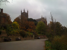
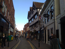
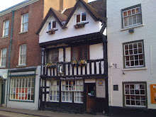
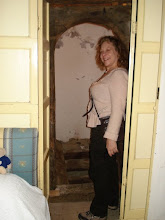
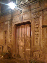
On Friday, October 30, Alice and I set out from Shropshire on the part of our journey that would follow Jane and Charles’s travels. Used to California highways, I had set what proved to be an unrealistically ambitious schedule for us.
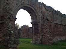
I had been sad to learn that Jane Lane’s home, Bentley Hall, near Walsall in Staffordshire, was no longer standing, but the helpful staff at Moseley Hall gave us directions to find a cairn that had been erected on the site, saying that it was opposite the Lane Arms pub.
When we got to the Bentley area, we were confused. The Lane Arms was unfortunately burned down, and though we looked for 20 or 30 minutes, we didn’t see a cairn, either across Wolverhampton Road or Queen Elizabeth Road. On the site where I thought the hall must have stood, just off the northeast corner of Wolverhampton Road and Queen Elizabeth Road, there was nothing but what looked like the beginning of a construction project. How depressing! Not only was Bentley Hall gone, but its remnants were going to be buried forever! It was also dispiriting to find that Bentley is now a somewhat grim corner of the outskirts of Birmingham.
Having come all the way from California to research the book, I didn’t want to give up without another try. We’d had good luck so far on the trip just asking local people to help us find places we were looking for, so we popped into the local Costcutter to ask if anyone knew anything about Bentley Hall. We were in luck! A lady told us that Pauline Gibson, who lived just down the street, knew everything about the area. So we intrepidly found the house and knocked on the door. No one home! A helpful neighbor promised to give Pauline my note, but didn’t know anything about Bentley Hall.
Now what to do? We didn’t know when Pauline might be back and we had a lot of ground to cover that day. Maybe the cairn had been pulled down or we were looking in the wrong place. But on a whim, I decided to make use of modern technology – my iPhone! I Googled “Bentley Hall Staffordshire,” and was amazed and pleased to find an article by Michael Shaw and Danny McAree about the rediscovery of the ruins of Bentley Hall only a few months earlier! We were in the right place, or pretty close. It was very exciting to realize that we were standing on or near the spot where Bentley Hall had been, where Charles II had arrived in the dead of night and set off with Jane Lane on their great adventure.
Pauline was kind enough to call me later in the day. Unfortunately by that point we were near Packington Hall in Warwickshire, where Jane lived later, when she married Sir Clement Fisher, and couldn’t go back to Bentley. But at least we knew we had been close.
Since then, I’ve found further information about the site on line. Apparently the cairn was there, we just didn’t go quite north enough of Wolverhampton Road.
I’ve also been delighted to discover historical maps online that give a pretty good idea of what the Bentley area must have looked like in 1651. It’s very interesting to see that the present day Wolverhampton Road still follows exactly the path it did then, and that the present Bentley Mill Lane is in fact where a little road ran from Bentley Hall, which was about a quarter mile north of the Wolverhampton Road, down to the mill.
Shaw and McAree’s article can be found at:
http://www.localhistory.scit.wlv.ac.uk/articles/Hall/BentleyHall.htm
Another article about Bentley Hall, “The Secrets of the Stone,” can be found at:
http://www.walsall.gov.uk/index/leisure_and_culture/parks_and_countryside/bentley_cairn_the_secrets_of_the_stone.htm
The 1805 ordnance map of the Bentley area, and other historical maps, can be seen at:
http://www.visionofbritain.org.uk/place/place_page.jsp?p_id=7881
On Friday, October 30, Alice and I set out from Shropshire on the part of our journey that would follow Jane and Charles’s travels. Used to California highways, I had set what proved to be an unrealistically ambitious schedule for us.
I had been sad to learn that Jane Lane’s home, Bentley Hall, near Walsall in Staffordshire, was no longer standing, but the helpful staff at Moseley Hall gave us directions to find a cairn that had been erected on the site, saying that it was opposite the Lane Arms pub.
When we got to the Bentley area, we were confused. The Lane Arms was unfortunately burned down, and though we looked for 20 or 30 minutes, we didn’t see a cairn, either across Wolverhampton Road or Queen Elizabeth Road. On the site where I thought the hall must have stood, just off the northeast corner of Wolverhampton Road and Queen Elizabeth Road, there was nothing but what looked like the beginning of a construction project. How depressing! Not only was Bentley Hall gone, but its remnants were going to be buried forever! It was also dispiriting to find that Bentley is now a somewhat grim corner of the outskirts of Birmingham.
Having come all the way from California to research the book, I didn’t want to give up without another try. We’d had good luck so far on the trip just asking local people to help us find places we were looking for, so we popped into the local Costcutter to ask if anyone knew anything about Bentley Hall. We were in luck! A lady told us that Pauline Gibson, who lived just down the street, knew everything about the area. So we intrepidly found the house and knocked on the door. No one home! A helpful neighbor promised to give Pauline my note, but didn’t know anything about Bentley Hall.
Now what to do? We didn’t know when Pauline might be back and we had a lot of ground to cover that day. Maybe the cairn had been pulled down or we were looking in the wrong place. But on a whim, I decided to make use of modern technology – my iPhone! I Googled “Bentley Hall Staffordshire,” and was amazed and pleased to find an article by Michael Shaw and Danny McAree about the rediscovery of the ruins of Bentley Hall only a few months earlier! We were in the right place, or pretty close. It was very exciting to realize that we were standing on or near the spot where Bentley Hall had been, where Charles II had arrived in the dead of night and set off with Jane Lane on their great adventure.
Pauline was kind enough to call me later in the day. Unfortunately by that point we were near Packington Hall in Warwickshire, where Jane lived later, when she married Sir Clement Fisher, and couldn’t go back to Bentley. But at least we knew we had been close.
Since then, I’ve found further information about the site on line. Apparently the cairn was there, we just didn’t go quite north enough of Wolverhampton Road.
I’ve also been delighted to discover historical maps online that give a pretty good idea of what the Bentley area must have looked like in 1651. It’s very interesting to see that the present day Wolverhampton Road still follows exactly the path it did then, and that the present Bentley Mill Lane is in fact where a little road ran from Bentley Hall, which was about a quarter mile north of the Wolverhampton Road, down to the mill.
Shaw and McAree’s article can be found at:
http://www.localhistory.scit.wlv.ac.uk/articles/Hall/BentleyHall.htm
Another article about Bentley Hall, “The Secrets of the Stone,” can be found at:
http://www.walsall.gov.uk/index/leisure_and_culture/parks_and_countryside/bentley_cairn_the_secrets_of_the_stone.htm
The 1805 ordnance map of the Bentley area, and other historical maps, can be seen at:
http://www.visionofbritain.org.uk/place/place_page.jsp?p_id=7881
Saturday, January 30, 2010
Hot Off the Presses
Curiously, just after I ordered the full-sized reprint of the map from The Natural History of Staffordshire, I discovered that The Malthouse Press has just published a reduced size edition of the book - about 5 by 8 inches, paperback, and unfortunately without the map and without many of the plates, but still a good find, and at $28.50 much more affordable than even the folio-sized modern facsimile of the whole book. I found it (and several other rare books I needed for this project) at Powells (powells.com), definitely worth a look!
The Malthouse Press
Grange Cottage, Malthouse Lane
Barlaston, Staffordshire ST12 9AQ, UK
timcockin@yahoo.com
(01782)372067
"The Pocket Plot" ISBN 978-0-953918-7-6
The Malthouse Press
Grange Cottage, Malthouse Lane
Barlaston, Staffordshire ST12 9AQ, UK
timcockin@yahoo.com
(01782)372067
"The Pocket Plot" ISBN 978-0-953918-7-6
Sunday, January 17, 2010
Maps. Maps, and More Maps
The Royal Miracle is very much about journeys. First Charles fled when he was routed at the Battle of Worcester. The first plan discussed among those with him was to escape back to Scotland. It rapidly became apparent that was too risky and that he would better off taking refuge at Whiteladies in Shropshire while his friend Lord Wilmot found a way for him to get out of the country. The two of them secretly agreed to separately make their way back to London and meet at the sign of the Three Cranes in the Vintry, asking for each other under the name Mr. Ashburnham. They didn't tell their friends their plans - indeed, their friends begged not to know their plans, so they couldn't be forced into disclosing them. Then Charles and Wilmot decided that the better plan was to cross the Severn River and get into Wales, which was less heavily occupied than England, and leave the country at Swansea or another port. But that plan was discarded when they learned that the river was heavily guarded and would be impossible to cross without capture.
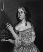
It was at this point that Jane came into the story. She had a pass for her and a manservant to travel from her home at Bentley, in Staffordshire, to Abbots Leigh, near Bristol, to visit a friend who was about to have a baby. Charles, disguised as that servant, made the trip with her, riding before her. When Bristol, too, was ruled out, they set out further south, to Trent in Dorset, with the intention of Charles finding a way out of the country at Weymouth in the south. Jane left Charles at Trent, believing him safe, but in fact it took another three weeks of running and hiding before he was able to set sail for France from Shoreham, near Brighthelmstone (now Brighton).
But Jane's travels weren't over when she got back to Bentley. She learned that her part in helping the King had been discovered, and that she, too, had to escape the country. So she and her brother walked to Yarmouth, on the east coast,and from there got passage to France.
But how did all this traveling take place? Charles's journey is pretty well documented, since many of the people involved later wrote accounts of the adventure, so that there are sometimes hour-by-hour, field-by-field descriptions of his route and what he did.
Jane's journey lies in shadows. And needless to say, the roads and means of travel in England have changed enormously since 1651. For instance, Birmingham, now the second largest city in England, is shown on period maps as a tiny hamlet, much smaller than Stafford, Lichfield, and even than Wolverhampton, Tamworth, and Newport.
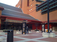
Fortunately, I've discovered a wealth of information that is helping me figure out what the country looked like and how Jane probably traveled. One excellent source is a book I found at the shop of the British Library, Maps for Historians by Paul Hindle. This pointed me in the direction of finding maps that shed a lot of light on Jane's path.
Robert Plot's The Natural History of Staffordshire (1686) includes a huge foldout map of Staffordshire (where Jane lived) and plates showing Stafford, Lichfield, and many of the principal estates in the county, including Bentley and Blithfield, the home of her grandparents Walter Bagot and Elizabeth Cave Bagot. I was able to borrow it through Interlibrary Loan (a fantastic service - ask at your local library if you're looking for hard-to-find books). I really wanted the map, but the price of the one original or the book I found (about $1000!) was a little prohibitive. Even used modern facsimiles of the book are going for about $200 on Alibris and ABE. Fortunately, I was able to order a reprint of the map from Reg Blagden through ABE for only $25, and also found A Staffordshire Armorial for 1680 by Richard Williams, a modern booklet offering further information on the various families whose coats of arms are displayed on Plot's map, which I bought from Richard Sylvanus Williams Books through ABE.
Another fantastic source I learned about from Hingle's book is John Ogilby's Britannia, a Roadmap of England and Wales from 1675. I had found copies of a 1970 reprint for sale starting at about $80, but was ecstatic to discover on Biblio.com that The Captain's Bookshelf in North Carolina had a 1939 reprint for $45, which proved to be in fantastic condition - 100 full-color plates of maps from Jane's time! Ogilby's format is a little odd - the roads are depicted on scrolls, about 6 side by side across a page, which you read from bottom to top. But he actually measured the distances, and the scale of the map is one inch to the mile, so they offer fantastic detail. And he sets forth all the principal routes a traveler of the time might have needed. One of these is Cambridge to Coventry, the reverse of which was probably part of the way Jane traveled to get from Bentley to Yarmouth.
I still have to get caught up and describe the part of my trip to England that involved following in Jane and Charles's footsteps as they traveled from Bentley to Long Marston in Warwickshire, then to Abbots Leigh, then to Trent in Dorset, which was invaluable in being able to evoke their trip, but these maps fill in the gaps and are really helping me place myself in Jane's shoes on the road in England in the fall and winter of 1651.
It was at this point that Jane came into the story. She had a pass for her and a manservant to travel from her home at Bentley, in Staffordshire, to Abbots Leigh, near Bristol, to visit a friend who was about to have a baby. Charles, disguised as that servant, made the trip with her, riding before her. When Bristol, too, was ruled out, they set out further south, to Trent in Dorset, with the intention of Charles finding a way out of the country at Weymouth in the south. Jane left Charles at Trent, believing him safe, but in fact it took another three weeks of running and hiding before he was able to set sail for France from Shoreham, near Brighthelmstone (now Brighton).
But Jane's travels weren't over when she got back to Bentley. She learned that her part in helping the King had been discovered, and that she, too, had to escape the country. So she and her brother walked to Yarmouth, on the east coast,and from there got passage to France.
But how did all this traveling take place? Charles's journey is pretty well documented, since many of the people involved later wrote accounts of the adventure, so that there are sometimes hour-by-hour, field-by-field descriptions of his route and what he did.
Jane's journey lies in shadows. And needless to say, the roads and means of travel in England have changed enormously since 1651. For instance, Birmingham, now the second largest city in England, is shown on period maps as a tiny hamlet, much smaller than Stafford, Lichfield, and even than Wolverhampton, Tamworth, and Newport.
Fortunately, I've discovered a wealth of information that is helping me figure out what the country looked like and how Jane probably traveled. One excellent source is a book I found at the shop of the British Library, Maps for Historians by Paul Hindle. This pointed me in the direction of finding maps that shed a lot of light on Jane's path.
Robert Plot's The Natural History of Staffordshire (1686) includes a huge foldout map of Staffordshire (where Jane lived) and plates showing Stafford, Lichfield, and many of the principal estates in the county, including Bentley and Blithfield, the home of her grandparents Walter Bagot and Elizabeth Cave Bagot. I was able to borrow it through Interlibrary Loan (a fantastic service - ask at your local library if you're looking for hard-to-find books). I really wanted the map, but the price of the one original or the book I found (about $1000!) was a little prohibitive. Even used modern facsimiles of the book are going for about $200 on Alibris and ABE. Fortunately, I was able to order a reprint of the map from Reg Blagden through ABE for only $25, and also found A Staffordshire Armorial for 1680 by Richard Williams, a modern booklet offering further information on the various families whose coats of arms are displayed on Plot's map, which I bought from Richard Sylvanus Williams Books through ABE.
Another fantastic source I learned about from Hingle's book is John Ogilby's Britannia, a Roadmap of England and Wales from 1675. I had found copies of a 1970 reprint for sale starting at about $80, but was ecstatic to discover on Biblio.com that The Captain's Bookshelf in North Carolina had a 1939 reprint for $45, which proved to be in fantastic condition - 100 full-color plates of maps from Jane's time! Ogilby's format is a little odd - the roads are depicted on scrolls, about 6 side by side across a page, which you read from bottom to top. But he actually measured the distances, and the scale of the map is one inch to the mile, so they offer fantastic detail. And he sets forth all the principal routes a traveler of the time might have needed. One of these is Cambridge to Coventry, the reverse of which was probably part of the way Jane traveled to get from Bentley to Yarmouth.
I still have to get caught up and describe the part of my trip to England that involved following in Jane and Charles's footsteps as they traveled from Bentley to Long Marston in Warwickshire, then to Abbots Leigh, then to Trent in Dorset, which was invaluable in being able to evoke their trip, but these maps fill in the gaps and are really helping me place myself in Jane's shoes on the road in England in the fall and winter of 1651.
Subscribe to:
Posts (Atom)